Search Results 263 items were found.
Keywords: town maps
-
- Item 11722
-

- Map of Brunswick, lots on Merrymeeting Bay, ca. 1750
- Contributed by: Maine Historical Society
- Date: circa 1750
- Location: Brunswick
- Media: Ink on paper
-
Buy


-
- Item 11730
-

- Map of Topsham, 1761
- Contributed by: Maine Historical Society
- Date: 1761-11-12
- Location: Topsham
- Media: Ink on paper
-
Buy
-
- Item 98903
-

- Map of Westport, 1857
- Contributed by: Westport Island History Committee
- Date: 1857
- Location: Westport Island
- Media: Ink on paper, photograph
-
Buy
-
- Item 58323
-

- Copy of Surry and Ellsworth map, ca. 1880
- Contributed by: Maine Historical Society
- Date: circa 1880
- Location: Ellsworth; Surry
- Media: Ink on paper
-
Buy
-
- Item 108858
-

- Plan of 200 acres on the Western Side of Kennebec River, Frankfort Plantation, 1758
- Contributed by: Maine Historical Society
- Date: 1758
- Location: Dresden
- Media: Ink on paper
-
Buy
-
- Item 11725
-

- Map of Brunswick, 1772
- Contributed by: Maine Historical Society
- Date: 1772
- Location: Brunswick
- Media: Ink on paper
-
Buy
-
- Item 10890
-

- Map of Portland, 1909
- Contributed by: Maine Historical Society
- Date: 1909
- Location: Portland
- Media: Ink on paper
-
Buy
-
- Item 71165
-

- Bird's-eye view of Pittsfield, looking northwest, 1889
- Contributed by: Boston Public Library
- Date: 1889
- Location: Pittsfield
- Media: Ink on paper, lithograph
-
Buy
-
- Item 71160
-

- Bird's-eye view of Dover-Foxcroft, 1878
- Contributed by: Boston Public Library
- Date: 1878
- Location: Dover-Foxcroft
- Media: Ink on paper, lithograph
-
Buy
-
- Item 11966
-

- Filling Back Cove, Portland, 1837-2003
- Contributed by: City of Portland Dept. of Public Works
- Date: 1837
- Location: Portland
- Media: Ink on paper, map
-
Buy
-
- Item 11962
-

- Vaughan Plan, ca. 1813
- Contributed by: City of Portland Dept. of Public Works
- Date: circa 1813
- Location: Portland
- Media: Ink on paper, map
-
Buy
-
- Item 11967
-

- Back Cove fill history, Portland, 1837-2003
- Contributed by: City of Portland Dept. of Public Works
- Date: 2003
- Location: Portland
- Media: Ink on paper, map
-
Buy
-
- Item 11717
-

- Brunswick, ca. 1718
- Contributed by: Maine Historical Society
- Date: circa 1718
- Location: Brunswick; Harpswell; Bath; Topsham
- Media: Ink on paper
-
Buy
-
- Item 6278
-

- The town of Falmouth, burnt by Capt. Moet, October 18, 1775
- Contributed by: Maine Historical Society
- Date: 1775-10-18
- Location: Portland
- Media: Photograph, map
-
Buy
-
- Item 11732
-

- Map of Topsham, ca. 1760
- Contributed by: Maine Historical Society
- Date: circa 1760
- Location: Topsham
- Media: Ink on paper
-
Buy
-
- Item 12411
-

- Samuel and Hugh Wilson survey, 1767
- Contributed by: Maine Historical Society
- Date: 1767
- Location: Brunswick
- Media: Ink on paper
-
Buy
-
- Item 71157
-

- Bird's-eye view of Caribou, 1893
- Contributed by: Boston Public Library
- Date: 1893
- Location: Caribou
- Media: Ink on paper, lithograph
-
Buy
-
- Item 11741
-

- Map of Harpswell, 1742
- Contributed by: Maine Historical Society
- Date: 1742
- Location: Harpswell
- Media: Ink on paper
-
Buy
-
- Item 21566
-

- Map of North Yarmouth, 1687
- Contributed by: Maine Historical Society
- Date: 1687
- Location: North Yarmouth
- Media: Ink on paper
-
Buy
-
- Item 20784
-
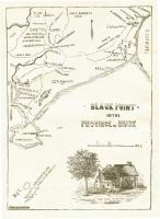
- Black Point, Scarborough, ca. 1633 - 1728
- Contributed by: Maine Historical Society
- Date: circa 1633
- Location: Scarborough
- Media: Ink on paper, map
-
Buy
-
- Item 12627
-

- Merryconeag and Maquoit marshes, ca. 1730
- Contributed by: Maine Historical Society
- Date: circa 1730
- Location: Brunswick
- Media: Ink on paper
-
Buy
-
- Item 71162
-

- Fort Fairfield bird's-eye view, 1893
- Contributed by: Boston Public Library
- Date: 1893
- Location: Fort Fairfield
- Media: Ink on paper, lithograph
-
Buy
-
- Item 100777
-

- Plan of North End of Bangor, 1844
- Contributed by: Maine Historical Society and Maine State Museum
- Date: 1844-03-11
- Location: Bangor
- Media: Ink and watercolor on paper
-
Buy
-
- Item 71156
-

- St. Stephen, New Brunswick, and Calais, 1889
- Contributed by: Boston Public Library
- Date: 1889
- Location: Calais; St. Stephen
- Media: Ink on paper, lithograph
-
Buy