Search Results 679 items were found.
Keywords: Maps.
-
- Item 110900
-

- Map detail for portions of Cornwall and Bug Islands, ca. 1820
- Contributed by: Maine Historical Society
- Date: circa 1820
- Location: Cornwall Island ; St. Regis Island
- Media: Graphite on paper
-
Buy


-
- Item 110997
-

- Map of the disputed portions of the New Brunswick and Lower Canada, 1839
- Contributed by: Maine Historical Society
- Date: 1839
- Media: Ink on paper
-
Buy
-
- Item 111022
-

- A plane chart of Rainy Lake, ca. 1820
- Contributed by: Maine Historical Society
- Date: circa 1820
- Media: Ink on paper
-
Buy
-
- Item 7533
-

- Map of Cape Elizabeth, Richmond Island area, 1884
- Contributed by: Maine Historical Society
- Date: circa 1630
- Location: Cape Elizabeth; Richmond Island
- Media: Ink on paper
-
Buy
-
- Item 12395
-

- Map of Wesserunsett stream, 1790
- Contributed by: Maine Historical Society
- Date: 1790-12-12
- Location: Canaan; Canaan
- Media: Ink on paper
-
Buy
-
- Item 100213
-

- Plan of Longfellow and Preble lots, Portland, 1838
- Contributed by: Maine Historical Society
- Date: 1838
- Location: Portland
- Media: Pencil on paper
-
Buy
-
- Item 58323
-

- Copy of Surry and Ellsworth map, ca. 1880
- Contributed by: Maine Historical Society
- Date: circa 1880
- Location: Ellsworth; Surry
- Media: Ink on paper
-
Buy
-
- Item 10545
-
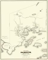
- Map of Ancient Falmouth from 1630 to 1690
- Contributed by: Maine Historical Society
- Date: circa 1630
- Location: Portland
- Media: Ink on paper
-
Buy
-
- Item 11830
-

- Map of the country explored, Maine and New Brunswick, ca. 1818
- Contributed by: Maine Historical Society
- Date: 1817
- Media: Ink on paper
-
Buy
-
- Item 12196
-

- Map of Kennebec Purchase lots, ca. 1750
- Contributed by: Maine Historical Society
- Date: circa 1750
- Media: Ink on paper
-
Buy
-
- Item 109000
-

- Dresden and Woolwich proposed border, ca. 1757
- Contributed by: Maine Historical Society
- Date: circa 1757
- Location: Woolwich; Dresden
- Media: Ink on paper
-
Buy
-
- Item 10763
-

- Chart of Casco Bay from the Atlantic Neptune, 1776
- Contributed by: Maine Historical Society
- Date: circa 1776
- Media: Ink on paper, map
-
Buy
-
- Item 5335
-

- Brunswick and Topsham, ca. 1730
- Contributed by: Maine Historical Society
- Date: circa 1730
- Location: Brunswick; Topsham
- Media: Ink on paper
-
Buy
-
- Item 5314
-

- Plan of rivers of Saco and Kennebunk, 1731
- Contributed by: Maine Historical Society
- Date: 1731
- Media: Ink on paper
-
Buy
-
- Item 35631
-

- Map of the city of Portsmouth, New Hampshire, 1850
- Contributed by: Maine Historical Society
- Date: 1850
- Location: Portsmouth; Kittery
- Media: Ink on paper
-
Buy
-
- Item 116515
-

- St. John River boundary survey, from Rose Island north and east, 1844
- Contributed by: Maine Historical Society
- Date: 1844
- Media: Ink on paper
-
Buy
-
- Item 11730
-

- Map of Topsham, 1761
- Contributed by: Maine Historical Society
- Date: 1761-11-12
- Location: Topsham
- Media: Ink on paper
-
Buy
-
- Item 116542
-

- A Map of Campobello and other islands in the Province of New Brunswick, 1830
- Contributed by: Maine Historical Society
- Date: 1830
- Location: Campobello Island
- Media: Ink on paper
-
Buy
-
- Item 11722
-

- Map of Brunswick, lots on Merrymeeting Bay, ca. 1750
- Contributed by: Maine Historical Society
- Date: circa 1750
- Location: Brunswick
- Media: Ink on paper
-
Buy
-
- Item 22214
-

- Map of Caribou, ca. 1870
- Contributed by: Aroostook County Historical and Art Museum
- Date: circa 1870
- Location: Caribou
- Media: Ink on paper
-
Buy
-
- Item 11725
-

- Map of Brunswick, 1772
- Contributed by: Maine Historical Society
- Date: 1772
- Location: Brunswick
- Media: Ink on paper
-
Buy
-
- Item 71160
-

- Bird's-eye view of Dover-Foxcroft, 1878
- Contributed by: Boston Public Library
- Date: 1878
- Location: Dover-Foxcroft
- Media: Ink on paper, lithograph
-
Buy
-
- Item 10890
-

- Map of Portland, 1909
- Contributed by: Maine Historical Society
- Date: 1909
- Location: Portland
- Media: Ink on paper
-
Buy
-
- Item 11966
-

- Filling Back Cove, Portland, 1837-2003
- Contributed by: City of Portland Dept. of Public Works
- Date: 1837
- Location: Portland
- Media: Ink on paper, map
-
Buy