Search Results 438 items were found.
LC Subject Heading: Maps
-
- Item 11754
-

- Plan for towns along the Androscoggin River, ca. 1760
- Contributed by: Maine Historical Society
- Date: circa 1760
- Media: Ink on paper
- Buy
-
- Item 11826
-

- Moses Greenleaf's map of the District of Maine, 1815
- Contributed by: Maine Historical Society
- Date: 1815
- Media: Ink on paper, map
- Buy
-
- Item 11964
-

- Map of the City and Harbor of Portland, 1870
- Contributed by: City of Portland Dept. of Public Works
- Date: 1870
- Media: Ink on paper, map
- Buy
-
- Item 12560
-

- Plan of lots on Sheepscot Pond, Palermo, 1806
- Contributed by: Maine Historical Society
- Date: 1806-06-27
- Media: Ink on paper
- Buy
-
- Item 12563
-

- Survey of settlers' lots in Norridgewock, 1802 and 1803
- Contributed by: Maine Historical Society
- Date: 1803
- Media: Ink on paper
- Buy
-
- Item 22214
-

- Map of Caribou, ca. 1870
- Contributed by: Aroostook County Historical and Art Museum
- Date: circa 1870
- Media: Ink on paper
- Buy
-
- Item 35632
-

- Map of the state of Maine, 1822
- Contributed by: Maine Historical Society
- Date: 1822
- Media: Ink on paper
- Buy
-
- Item 68866
-

- Libby River land, Scarborough, 1794
- Contributed by: Maine Historical Society
- Date: 1794
- Media: Ink on paper, map
- Buy
-
- Item 68871
-

- Second parish of Scarborough, 1798
- Contributed by: Maine Historical Society
- Date: 1798
- Media: Ink on paper
- Buy
-
- Item 100725
-

- Plan of Portland, 1858
- Contributed by: Maine Historical Society
- Date: 1858
- Media: Lithograph with hand-coloring
- Buy
-
- Item 108831
-

- Lot plans, Vassalboro, 1774
- Contributed by: Maine Historical Society
- Date: 1774-03-29
- Media: Ink on paper
- Buy
-
- Item 110907
-

- Kennebec River, ca. 1800
- Contributed by: Maine Historical Society
- Date: circa 1812
- Media: Ink on paper
- Buy
-
- Item 110945
-

- International water boundary between the United States and the Dominion of Canada, ca. 1893
- Contributed by: Maine Historical Society
- Date: 1893
- Media: Ink on paper
- Buy
-
- Item 116516
-

- Extract from a Map of the British and French Dominions in North America, 1755
- Contributed by: Maine Historical Society
- Date: circa 1755
- Media: Ink on paper
- Buy
-
- Item 149687
-

- Map of Maine, ca. 1831
- Contributed by: Acadian Archives
- Date: circa 1831
- Media: Ink on paper
- Buy
-
- Item 4318
-

- Androscoggin River above Lewiston, ca. 1750
- Contributed by: Maine Historical Society
- Date: circa 1750
- Media: Ink on paper
- Buy
-
- Item 11454
-

- Fort Land, Brunswick, 1763
- Contributed by: Maine Historical Society
- Date: 1763-08-11
- Media: Ink on paper
- Buy
-
- Item 11830
-

- Map of the country explored, Maine and New Brunswick, ca. 1818
- Contributed by: Maine Historical Society
- Date: 1817
- Media: Ink on paper
- Buy
-
- Item 4316
-

- Plan of J. Robinson lot, Topsham, 1761
- Contributed by: Maine Historical Society
- Date: 1761
- Media: Ink on paper
- Buy
-
- Item 4325
-

- "Brunswick in the late Province of Mayne in New England," 1719
- Contributed by: Maine Historical Society
- Date: 1718-01-28
- Media: Ink on paper
- Buy
-
- Item 6315
-

- Moosehead Lake, 1879
- Contributed by: Maine Historical Society
- Date: circa 1880
- Media: Map
- Buy
-
- Item 9166
-

- District of Maine map, 1795
- Contributed by: Maine Historical Society
- Date: 1795
- Media: Ink on paper
- Buy
-
- Item 10545
-
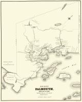
- Map of Ancient Falmouth from 1630 to 1690
- Contributed by: Maine Historical Society
- Date: circa 1630
- Media: Ink on paper
- Buy
-
- Item 17126
-

- Sketch Map of Pascataqua, ca. 1690
- Contributed by: Maine Historical Society
- Date: circa 1690
- Media: Ink on paper, map
- Buy