Search Results 197 items were found.
Keywords: Early works to 1800.
-
- Item 11758
-

- Samuel and Hugh Wilson's lot in Topsham, 1758
- Contributed by: Maine Historical Society
- Date: 1758
- Media: Ink on paper
- Buy
-
- Item 11979
-

- Norridgewock Fort and Kennebec River, 1719
- Contributed by: Maine Historical Society
- Date: 1719
- Media: Ink on paper
- Buy
-
- Item 4168
-

- Plan of Falmouth Neck, 1690
- Contributed by: Maine Historical Society
- Date: 1690
- Media: Ink on paper
- Buy
-
- Item 6883
-

- St. John and Penobscot Rivers map, 1798
- Contributed by: Maine Historical Society
- Date: 1798-05-08
- Media: Ink on paper
- Buy
-
- Item 33847
-

- Champlain's map of Saco Bay and the Saco River, 1605
- Contributed by: McArthur Public Library
- Date: 1605
- Media: Photographic print
- Buy
-
- Item 11746
-

- Merriconeag Neck, 1749
- Contributed by: Maine Historical Society
- Date: 1749-07-04
- Media: Ink on paper
- Buy
-
- Item 11754
-

- Plan for towns along the Androscoggin River, ca. 1760
- Contributed by: Maine Historical Society
- Date: circa 1760
- Media: Ink on paper
- Buy
-
- Item 11925
-

- Seven lots on the Androscoggin River, 1771
- Contributed by: Maine Historical Society
- Date: 1771
- Media: Ink on paper
- Buy
-
- Item 108959
-

- Plat of a tract of land in Woolwich, 1751
- Contributed by: Patten Free Library
- Date: 1751-11-29
- Media: Watercolor on paper
- Buy
-
- Item 6851
-

- Chief Wasp map of Lake Vermillion, Sandy Point, ca. 1820
- Contributed by: Maine Historical Society
- Date: circa 1825
- Media: Graphite on paper
- Buy
-
- Item 116516
-

- Extract from a Map of the British and French Dominions in North America, 1755
- Contributed by: Maine Historical Society
- Date: circa 1755
- Media: Ink on paper
- Buy
-
- Item 4182
-

- Plan of Rascoheegan alias Parker's Island, 1759
- Contributed by: Maine Historical Society
- Date: 1759
- Media: Ink on paper
- Buy
-
- Item 20784
-
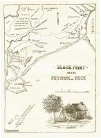
- Black Point, Scarborough, ca. 1633 - 1728
- Contributed by: Maine Historical Society
- Date: circa 1633
- Media: Ink on paper, map
- Buy
-
- Item 109022
-

- Disputed lot E, Brunswick, 1811
- Contributed by: Maine Historical Society
- Date: 1811-09-03
- Media: Ink on paper
- Buy
-
- Item 6278
-

- The town of Falmouth, burnt by Capt. Moet, October 18, 1775
- Contributed by: Maine Historical Society
- Date: 1775-10-18
- Media: ink on paper
- Buy
-
- Item 6843
-

- A map of the boundary line explored in 1817
- Contributed by: Maine Historical Society
- Date: 1817
- Media: Ink on paper
- Buy
-
- Item 108839
-

- Plat of a tract of land situated on the west side of Long Reach, Bath, 1771
- Contributed by: Maine Historical Society
- Date: 1771
- Media: Ink on paper
- Buy
-
- Item 108862
-

- Survey of lots for Peter Brown, Georgetown, 1761
- Contributed by: Maine Historical Society
- Date: 1761-01-12
- Media: Ink on paper
- Buy
-
- Item 102767
-

- Copy of a plan of lands on the west side of Madomack River, Waldoboro, 1774
- Contributed by: Maine Historical Society
- Date: 1774
- Media: Ink on paper
- Buy
-
- Item 102072
-

- Plan of Royalsborough, ca. 1766
- Contributed by: Maine Historical Society
- Date: circa 1766
- Media: Ink on vellum
- Buy
-
- Item 108848
-

- Map and petition, Sandy River, 1798
- Contributed by: Maine Historical Society
- Date: 1798
- Media: Ink on paper
- Buy
-
- Item 110355
-

- Survey of lots, Georgetown, 1793
- Contributed by: Maine Historical Society
- Date: circa 1780
- Media: Ink on paper
- Buy
-
- Item 108846
-

- Land request, West Bath, 1760
- Contributed by: Maine Historical Society
- Date: 1760-04-08
- Media: Ink on paper
- Buy
-
- Item 108844
-

- Plan of lots in Georgetown, 1759
- Contributed by: Maine Historical Society
- Date: 1759-03-14
- Media: Ink on paper
- Buy