Search Results 424 items were found.
LC Subject Heading: Maps
-
- Item 59770
-

- Portland, South Portland, & Cape Elizabeth electric railroads, ca. 1941
- Contributed by: Seashore Trolley Museum
- Date: circa 1941
- Location: Portland
- Media: Ink on paper
-
Buy


-
- Item 59772
-

- Electric railroad route map, ca. 1933
- Contributed by: Seashore Trolley Museum
- Date: circa 1933
- Location: Portland; Falmouth; Yarmouth; Cumberland
- Media: Ink on paper
-
Buy
-
- Item 102069
-

- Early map of Lewiston, Auburn and Minot, 1820
- Contributed by: Maine Historical Society
- Date: 1820
- Location: Lewiston; Auburn; Minot
- Media: Ink on paper
-
Buy
-
- Item 4176
-

- Falmouth Neck before burning, 1775
- Contributed by: Maine Historical Society
- Date: 1775-10-18
- Location: Portland
- Media: Paper
-
Buy
-
- Item 5179
-

- Eastern Cemetery, Portland, 1889
- Contributed by: Maine Historical Society
- Date: 1889
- Location: Portland
- Media: Blueprint
-
Buy
-
- Item 12558
-

- Skowhegan Falls, ca. 1800
- Contributed by: Maine Historical Society
- Date: circa 1800
- Location: Skowhegan
- Media: Ink on paper
-
Buy
-
- Item 24024
-

- Mount Desert Island, 1936
- Contributed by: Jesup Memorial Library
- Date: 1936
- Media: Postcard
-
Buy
-
- Item 35633
-

- Map of the state of Maine, 1843
- Contributed by: Maine Historical Society
- Date: 1843
- Media: Ink on paper
-
Buy
-
- Item 68874
-

- Sheepscot Farms, Wiscasset, 1877
- Contributed by: Maine Historical Society
- Date: 1877
- Location: Wiscasset
- Media: Ink on paper
-
Buy
-
- Item 6849
-

- Hallowell, 1794
- Contributed by: Maine Historical Society
- Date: 1794
- Location: Augusta; Hallowell
- Media: Ink on paper
-
Buy
-
- Item 9260
-

- Map of ice houses along the Kennebec River, 1891
- Contributed by: Maine Historical Society
- Date: 1891
- Media: Ink on paper
-
Buy
-
- Item 10887
-

- Map from Hay's Guide to Portland and Motoring in Maine, 1928
- Contributed by: Maine Historical Society
- Date: 1928
- Media: Ink on paper, map
-
Buy
-
- Item 25025
-

- Luke Lambard to U.S. Marshall Thornton about 1820 census, Bath, 1820
- Contributed by: Maine Historical Society
- Date: 1820
- Location: Georgetown; Woolwich; Dresden
- Media: Ink on paper
-
Buy
-
- Item 28910
-

- Pepperell Manufacturing fire insurance map, 1929
- Contributed by: McArthur Public Library
- Date: 1929-10-10
- Location: Biddeford
- Media: Ink on paper
-
Buy
-
- Item 34294
-

- Town Map with School Locations, Scarborough, ca. 1940
- Contributed by: Scarborough Historical Society & Museum
- Date: circa 1940
- Location: Scarborough
- Media: Photograph, ink on paper
-
Buy
-
- Item 35628
-

- Map of 1866 Portland Fire, 1866
- Contributed by: Maine Historical Society
- Date: 1866-07-04
- Location: Portland
- Media: Ink on paper
-
Buy
-
- Item 59764
-

- Kittery to York Beach electric railroad lines, ca. 1923
- Contributed by: Seashore Trolley Museum
- Date: circa 1923
- Location: York; Kittery
- Media: Ink on paper
-
Buy
-
- Item 100726
-

- Plan of Portland enhanced with school districts, ca. 1858
- Contributed by: Maine Historical Society
- Date: circa 1858
- Location: Portland
- Media: Lithograph with hand coloring
-
Buy
-
- Item 100727
-

- Portland street map, 1826
- Contributed by: Maine Historical Society
- Date: 1826
- Location: Portland
- Media: Watercolor and pen and ink, mounted on fabric
-
Buy
-
- Item 108765
-

- Edward Little plan of lots, ca. 1820
- Contributed by: Maine Historical Society
- Date: circa 1820
- Media: Ink on paper
-
Buy
-
- Item 108767
-

- Plan of land in Brunswick, ca. 1800
- Contributed by: Maine Historical Society
- Date: circa 1800
- Location: Brunswick
- Media: Ink on paper
-
Buy
-
- Item 108959
-

- Plat of a tract of land in Woolwich, 1751
- Contributed by: Patten Free Library
- Date: 1751-11-29
- Location: Woolwich
- Media: Watercolor on paper
-
Buy
-
- Item 5314
-

- Plan of rivers of Saco and Kennebunk, 1731
- Contributed by: Maine Historical Society
- Date: 1731
- Media: Ink on paper
-
Buy
-
- Item 20784
-
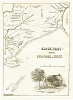
- Black Point, Scarborough, ca. 1633 - 1728
- Contributed by: Maine Historical Society
- Date: circa 1633
- Location: Scarborough
- Media: Ink on paper, map
-
Buy