Search Results 438 items were found.
LC Subject Heading: Maps
-
- Item 108959
-

- Plat of a tract of land in Woolwich, 1751
- Contributed by: Patten Free Library
- Date: 1751-11-29
- Media: Watercolor on paper
- Buy
-
- Item 5314
-

- Plan of rivers of Saco and Kennebunk, 1731
- Contributed by: Maine Historical Society
- Date: 1731
- Media: Ink on paper
- Buy
-
- Item 20784
-
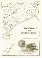
- Black Point, Scarborough, ca. 1633 - 1728
- Contributed by: Maine Historical Society
- Date: circa 1633
- Media: Ink on paper, map
- Buy
-
- Item 58324
-

- Mount Vernon land controversy, ca. 1806
- Contributed by: Maine Historical Society
- Date: 1806
- Media: Ink on paper
- Buy
-
- Item 148262
-

- Map of highways, rivers, bridges, and houses of worship in Falmouth, together with public and private buildings, Portland, ca. 1804
- Contributed by: Maine Historical Society
- Date: circa 1804
- Media: ink on paper
- Buy
-
- Item 4171
-

- Great fire of Portland, 1866
- Contributed by: Maine Historical Society
- Date: 1866-07-04
- Media: Ink on paper
- Buy
-
- Item 11962
-

- Vaughan Plan, ca. 1813
- Contributed by: City of Portland Dept. of Public Works
- Date: circa 1813
- Media: Ink on paper, map
- Buy
-
- Item 12398
-

- Early map of the Sheepscot River, 1816
- Contributed by: Maine Historical Society
- Date: 1816-01-08
- Media: Ink on paper
- Buy
-
- Item 5335
-

- Brunswick and Topsham, ca. 1730
- Contributed by: Maine Historical Society
- Date: circa 1730
- Media: Ink on paper
- Buy
-
- Item 12939
-

- Henry May, James Larking lot, near the Sheepscot River, 1805
- Contributed by: Maine Historical Society
- Date: 1805-11-25
- Media: Ink on paper
- Buy
-
- Item 109022
-

- Disputed lot E, Brunswick, 1811
- Contributed by: Maine Historical Society
- Date: 1811-09-03
- Media: Ink on paper
- Buy
-
- Item 110913
-

- "Part of Bug Island" map fragment, ca. 1823
- Contributed by: Maine Historical Society
- Date: circa 1823
- Media: Ink on paper
- Buy
-
- Item 8562
-

- Treaty of Washington boundary map, 1842
- Contributed by: Maine Historical Society
- Date: 1842
- Media: Ink on paper
- Buy
-
- Item 8563
-

- British survey highlands map, ca. 1840
- Contributed by: Maine Historical Society
- Date: circa 1840
- Media: Ink on paper
- Buy
-
- Item 9714
-

- Nouvelle Ecosse ou Partie orientale du Canada, 1778
- Contributed by: Acadian Archives
- Date: 1778
- Media: Ink on paper
- Buy
-
- Item 11963
-

- Plan of the City of Portland, 1837
- Contributed by: City of Portland Dept. of Public Works
- Date: 1837
- Media: Ink on paper, map
- Buy
-
- Item 12571
-

- Malta lot, 1810
- Contributed by: Maine Historical Society
- Date: 1810-06-15
- Media: Ink on paper
- Buy
-
- Item 17584
-

- Map of Mt. Ktaadn, 1917
- Contributed by: Maine Historical Society
- Date: 1917
- Media: Ink on paper
- Buy
-
- Item 23348
-

- Map showing approaches to Mount Desert, 1903
- Contributed by: Maine Historical Society
- Date: 1903
- Media: Ink on paper, map
- Buy
-
- Item 110888
-

- Map of the Northern part of the state of Maine and of the adjacent British Provinces, 1830
- Contributed by: Maine Historical Society
- Date: circa 1830
- Media: Ink on paper
- Buy
-
- Item 149685
-

- Province of Maine, 1799
- Contributed by: Acadian Archives
- Date: 1799
- Media: Ink on paper
- Buy
-
- Item 176
-

- Plan of Portland, engraved as a directory, 1852
- Contributed by: Maine Historical Society
- Date: 1852
- Media: Ink on paper
- Buy
-
- Item 4323
-

- "Scituate," Brunswick, 1738
- Contributed by: Maine Historical Society
- Date: 1738
- Media: Ink on paper
- Buy
-
- Item 6893
-

- A new and correct plan of Portland, 1823
- Contributed by: Maine Historical Society
- Date: 1823
- Media: Ink on paper
- Buy