Search Results 218 items were found.
Keywords: Maps, Early
-
- Item 102073
-

- Map of Lewiston and Auburn, 1851
- Contributed by: Maine Historical Society
- Date: 1851
- Location: Lewiston; Auburn
- Media: Ink on paper
-
Buy


-
- Item 6843
-

- A map of the boundary line explored in 1817
- Contributed by: Maine Historical Society
- Date: 1817
- Media: Ink on paper
-
Buy
-
- Item 12395
-

- Map of Wesserunsett stream, 1790
- Contributed by: Maine Historical Society
- Date: 1790-12-12
- Location: Canaan; Canaan
- Media: Ink on paper
-
Buy
-
- Item 5956
-

- Estate of William Skinner, Topsham, 1766
- Contributed by: Maine Historical Society
- Date: 1766-06-15
- Location: Topsham
- Media: Ink on paper
-
Buy
-
- Item 12940
-

- Map of lots G1 and G2 for James Pitts, near Clinton, 1769
- Contributed by: Maine Historical Society
- Date: 1769-11-07
- Location: Skowhegan
- Media: Ink on paper
-
Buy
-
- Item 11722
-

- Map of Brunswick, lots on Merrymeeting Bay, ca. 1750
- Contributed by: Maine Historical Society
- Date: circa 1750
- Location: Brunswick
- Media: Ink on paper
-
Buy
-
- Item 5343
-

- Lot #1 in Harpswell, 1743
- Contributed by: Maine Historical Society
- Date: 1743
- Location: Harpswell
- Media: Ink on paper
-
Buy
-
- Item 12411
-

- Samuel and Hugh Wilson survey, 1767
- Contributed by: Maine Historical Society
- Date: 1767
- Location: Brunswick
- Media: Ink on paper
-
Buy
-
- Item 12627
-

- Merryconeag and Maquoit marshes, ca. 1730
- Contributed by: Maine Historical Society
- Date: circa 1730
- Location: Brunswick
- Media: Ink on paper
-
Buy
-
- Item 12203
-

- Benjamin and Nehemiah Turner's plan containing 200 acres, Palermo, 1806
- Contributed by: Maine Historical Society
- Date: 1806-06-18
- Location: Palermo
- Media: Ink on paper
-
Buy
-
- Item 13074
-

- Manuscript map of Kennebec River area, 1771
- Contributed by: Maine Historical Society
- Date: 1771
- Media: Ink on paper
-
Buy
-
- Item 12855
-

- Plan of Cumberland and Lincoln counties, 1773
- Contributed by: Maine Historical Society
- Date: 1773
- Media: Ink on paper
-
Buy
-
- Item 5890
-

- Sara Cotta's lot, Brunswick, 1731
- Contributed by: Maine Historical Society
- Date: 1731
- Location: Brunswick
- Media: Ink on paper
-
Buy
-
- Item 66609
-

- Map of Mt. Desert Island printed on postcard, ca. 1935
- Contributed by: Boston Public Library
- Date: circa 1935
- Location: Mount Desert Island
- Media: Linen texture postcard
-
Buy
-
- Item 21566
-

- Map of North Yarmouth, 1687
- Contributed by: Maine Historical Society
- Date: 1687
- Location: North Yarmouth
- Media: Ink on paper
-
Buy
-
- Item 11717
-

- Brunswick, ca. 1718
- Contributed by: Maine Historical Society
- Date: circa 1718
- Location: Brunswick; Harpswell; Bath; Topsham
- Media: Ink on paper
-
Buy
-
- Item 11741
-

- Map of Harpswell, 1742
- Contributed by: Maine Historical Society
- Date: 1742
- Location: Harpswell
- Media: Ink on paper
-
Buy
-
- Item 100725
-

- Plan of Portland, 1858
- Contributed by: Maine Historical Society
- Date: 1858
- Location: Portland
- Media: Lithograph with hand-coloring
-
Buy
-
- Item 12941
-

- Plan of the Kennebec River, Nov. 1763
- Contributed by: Maine Historical Society
- Date: 1763
- Location: Richmond
- Media: Ink on paper
-
Buy
-
- Item 108848
-

- Map and petition, Sandy River, 1798
- Contributed by: Maine Historical Society
- Date: 1798
- Location: New Vineyard; Farmington
- Media: Ink on paper
-
Buy
-
- Item 105015
-

- Figure de la Terre Neuve, grande riviere de Canada, et cotes de l'ocean en la Nouvelle France, 1618
- Contributed by: Maine Historical Society
- Date: 1607
- Media: Ink on paper
-
Buy
-
- Item 20784
-
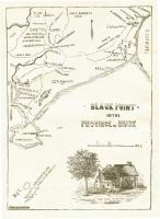
- Black Point, Scarborough, ca. 1633 - 1728
- Contributed by: Maine Historical Society
- Date: circa 1633
- Location: Scarborough
- Media: Ink on paper, map
-
Buy
-
- Item 10537
-

- Mare Point, Brunswick, 1717
- Contributed by: Maine Historical Society
- Date: 1717
- Location: Brunswick
- Media: Ink on paper
-
Buy
-
- Item 9359
-

- Maine, from the United States Gazetteer, 1795
- Contributed by: Maine Historical Society
- Date: 1795
- Media: Ink on paper
-
Buy