Search Results 679 items were found.
Keywords: Map
-
- Item 116504
-

- Manuscript Map of Lake Ontario, 1819
- Contributed by: Maine Historical Society
- Date: 1819
- Media: Ink on paper
-
Buy


-
- Item 7533
-

- Map of Cape Elizabeth, Richmond Island area, 1884
- Contributed by: Maine Historical Society
- Date: circa 1630
- Location: Cape Elizabeth; Richmond Island
- Media: Ink on paper
-
Buy
-
- Item 35631
-

- Map of the city of Portsmouth, New Hampshire, 1850
- Contributed by: Maine Historical Society
- Date: 1850
- Location: Portsmouth; Kittery
- Media: Ink on paper
-
Buy
-
- Item 116503
-

- Manuscript map of Lake St. Clair, 1820
- Contributed by: Maine Historical Society
- Date: 1820
- Media: Ink on paper
-
Buy
-
- Item 10545
-
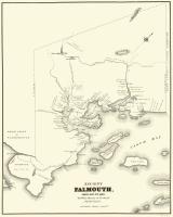
- Map of Ancient Falmouth from 1630 to 1690
- Contributed by: Maine Historical Society
- Date: circa 1630
- Location: Portland
- Media: Ink on paper
-
Buy
-
- Item 116488
-

- A New Map of the Province of Lower Canada, 1838
- Contributed by: Maine Historical Society
- Date: 1838
- Media: Ink on paper
-
Buy
-
- Item 11722
-

- Map of Brunswick, lots on Merrymeeting Bay, ca. 1750
- Contributed by: Maine Historical Society
- Date: circa 1750
- Location: Brunswick
- Media: Ink on paper
-
Buy
-
- Item 110963
-

- Map of Lake St. Lawrence, 1820
- Contributed by: Maine Historical Society
- Date: 1814
- Media: Ink on paper
-
Buy
-
- Item 110967
-

- Map of Islands on Lake Huron, ca. 1820
- Contributed by: Maine Historical Society
- Date: circa 1820
- Location: Drummond
- Media: Ink on paper
-
Buy
-
- Item 11963
-

- Plan of the City of Portland, 1837
- Contributed by: City of Portland Dept. of Public Works
- Date: 1837
- Location: Portland
- Media: Ink on paper, map
-
Buy
-
- Item 58323
-

- Copy of Surry and Ellsworth map, ca. 1880
- Contributed by: Maine Historical Society
- Date: circa 1880
- Location: Ellsworth; Surry
- Media: Ink on paper
-
Buy
-
- Item 6851
-

- Chief Wasp map of Lake Vermillion, Sandy Point, ca. 1820
- Contributed by: Maine Historical Society
- Date: circa 1825
- Media: Graphite on paper
-
Buy
-
- Item 51266
-

- A.W. Longfellow map of Presumpscot River, Windham, 1840
- Contributed by: Maine Historical Society
- Date: 1840
- Location: Westbrook
- Media: Ink on paper
-
Buy
-
- Item 12937
-

- Map of lot no. 7, 135 acres on Madison Road, Skowhegan, ca. 1760
- Contributed by: Maine Historical Society
- Date: circa 1760
- Location: Skowhegan
- Media: Ink on paper
-
Buy
-
- Item 7489
-

- Nova Anglia, Novum Belgium et Virginia, ca. 1642
- Contributed by: Maine Historical Society
- Date: circa 1642
- Media: Map, ink on paper
-
Buy
-
- Item 116523
-

- Manuscript map of Cape Hurd, Lake Huron, ca. 1820
- Contributed by: Maine Historical Society
- Date: circa 1820
- Media: Ink on paper
-
Buy
-
- Item 11830
-

- Map of the country explored, Maine and New Brunswick, ca. 1818
- Contributed by: Maine Historical Society
- Date: 1817
- Media: Ink on paper
-
Buy
-
- Item 7492
-

- Novi Belgii: Novaeque Angliae Nec Non partis Virginiae, ca. 1655
- Contributed by: Maine Historical Society
- Date: circa 1655
- Media: Map, ink on paper
-
Buy
-
- Item 110913
-

- "Part of Bug Island" map fragment, ca. 1823
- Contributed by: Maine Historical Society
- Date: circa 1823
- Media: Ink on paper
-
Buy
-
- Item 116495
-

- Manuscript map of Loon's Narrows & Lac Du Bois, ca. 1822
- Contributed by: Maine Historical Society
- Date: circa 1822
- Media: Ink on paper
-
Buy
-
- Item 116516
-

- Extract from a Map of the British and French Dominions in North America, 1755
- Contributed by: Maine Historical Society
- Date: circa 1755
- Media: Ink on paper
-
Buy
-
- Item 116542
-

- A Map of Campobello and other islands in the Province of New Brunswick, 1830
- Contributed by: Maine Historical Society
- Date: 1830
- Location: Campobello Island
- Media: Ink on paper
-
Buy
-
- Item 110997
-

- Map of the disputed portions of the New Brunswick and Lower Canada, 1839
- Contributed by: Maine Historical Society
- Date: 1839
- Media: Ink on paper
-
Buy
-
- Item 4181
-

- Moosehead Lake area map, 1874
- Contributed by: Maine Historical Society
- Date: 1874
- Media: Paper
-
Buy