Search Results 429 items were found.
Category: Nature & Geography, Maps
-
- Item 109000
-

- Dresden and Woolwich proposed border, ca. 1757
- Contributed by: Maine Historical Society
- Date: circa 1757
- Location: Woolwich; Dresden
- Media: Ink on paper
-
Buy


-
- Item 109026
-

- Abagadassat Mill lots, Bowdoinham, 1755
- Contributed by: Maine Historical Society
- Date: 1755
- Location: Bowdoinham
- Media: Ink on paper
-
Buy
-
- Item 110949
-

- Boundary survey between New Brunswick and Maine, 1842
- Contributed by: Maine Historical Society
- Date: 1842
- Media: Ink on paper
-
Buy
-
- Item 176
-

- Plan of Portland, engraved as a directory, 1852
- Contributed by: Maine Historical Society
- Date: 1852
- Location: Portland
- Media: Ink on paper
-
Buy
-
- Item 4168
-

- Plan of Falmouth Neck, 1690
- Contributed by: Maine Historical Society
- Date: 1690
- Location: Portland
- Media: Ink on paper
-
Buy
-
- Item 4171
-

- Great fire of Portland, 1866
- Contributed by: Maine Historical Society
- Date: 1866-07-04
- Location: Portland
- Media: Ink on paper
-
Buy
-
- Item 4173
-

- Plan of Portland, 1866
- Contributed by: Maine Historical Society
- Date: 1866
- Location: Portland
- Media: Ink on paper
-
Buy
-
- Item 4174
-

- Map of Portland and vicinity, 1900
- Contributed by: Maine Historical Society
- Date: 1900
- Location: Portland
- Media: Paper
-
Buy
-
- Item 4175
-

- Plan of the City of Portland, 1837
- Contributed by: Maine Historical Society
- Date: 1837
- Location: Portland
- Media: Paper
-
Buy
-
- Item 4177
-

- Province of Maine, ca. 1801
- Contributed by: Maine Historical Society
- Date: circa 1801
- Media: Paper
-
Buy
-
- Item 5330
-

- The Pejepscot Claim, September 15, 1764
- Contributed by: Maine Historical Society
- Date: 1764-09-15
- Location: Brunswick; Topsham; Freeport; Harpswell; Lewiston; North Yarmouth
- Media: Ink on paper
-
Buy
-
- Item 7533
-

- Map of Cape Elizabeth, Richmond Island area, 1884
- Contributed by: Maine Historical Society
- Date: circa 1630
- Location: Cape Elizabeth; Richmond Island
- Media: Ink on paper
-
Buy
-
- Item 7540
-

- Map of the New England Coast, 1610
- Contributed by: Maine Historical Society
- Date: 1610
- Media: Ink on paper
-
Buy
-
- Item 8564
-

- North shore, Lake Huron, ca. 1819
- Contributed by: Maine Historical Society
- Date: circa 1819
- Media: Ink on paper
-
Buy
-
- Item 9166
-

- District of Maine map, 1795
- Contributed by: Maine Historical Society
- Date: 1795
- Media: Ink on paper
-
Buy
-
- Item 9359
-

- Maine, from the United States Gazetteer, 1795
- Contributed by: Maine Historical Society
- Date: 1795
- Media: Ink on paper
-
Buy
-
- Item 10545
-
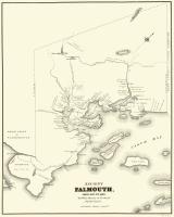
- Map of Ancient Falmouth from 1630 to 1690
- Contributed by: Maine Historical Society
- Date: circa 1630
- Location: Portland
- Media: Ink on paper
-
Buy
-
- Item 10884
-

- Street guide of Portland, 1928
- Contributed by: Maine Historical Society
- Date: 1928
- Location: Portland
- Media: Ink on paper, map
-
Buy
-
- Item 10890
-

- Map of Portland, 1909
- Contributed by: Maine Historical Society
- Date: 1909
- Location: Portland
- Media: Ink on paper
-
Buy
-
- Item 11826
-

- Moses Greenleaf's map of the District of Maine, 1815
- Contributed by: Maine Historical Society
- Date: 1815
- Media: Ink on paper, map
-
Buy
-
- Item 11830
-

- Map of the country explored, Maine and New Brunswick, ca. 1818
- Contributed by: Maine Historical Society
- Date: 1817
- Media: Ink on paper
-
Buy
-
- Item 11961
-

- Location of wharves in Portland Harbor, 2001
- Contributed by: City of Portland Dept. of Public Works
- Date: 2001
- Location: Portland
- Media: Ink on paper, map
-
Buy
-
- Item 11963
-

- Plan of the City of Portland, 1837
- Contributed by: City of Portland Dept. of Public Works
- Date: 1837
- Location: Portland
- Media: Ink on paper, map
-
Buy
-
- Item 11965
-

- Portland map, 1773
- Contributed by: City of Portland Dept. of Public Works
- Date: 1773
- Location: Portland
- Media: Ink on paper, map
-
Buy